With the implementation of the strategy to build a country with strong transportation network and the development of a high-quality comprehensive national transport network, transport corridors have become a key issue in transport geography. This paper systematically reviews the evolution of topics and conceptual connotations related to transport corridors, and synthesizes existing studies focusing on evolutionary mechanisms, impacts, and development evaluation. The results indicate: 1) The evolution of transport corridors follows a four-stage pattern: node cultivation, axis development, corridor formation, and system optimization, driven by transport demand, policy regulation, technological innovation, and environmental constraints. 2) The impacts of transport corridors include the restructuring of natural spaces, enhancement of socio-spatial interactions, and shaping of political spaces. 3) Current evaluations of transport corridors mainly focus on service quality, safety risks, and spatial structure. Furthermore, this paper summarizes three major shifts in recent research, and identifies several research gaps, such as limited understanding of spatial heterogeneity mechanisms, insufficient analysis of corridor network synergy, inadequate attention to lowcarbon transition or spatial equity, and underdeveloped integration of frontier technologies. From a geographical perspective, this study puts forward four research prospects, aiming to offer insights for theoretical exploration of transport corridors, as well as the high-quality development of transport systems and territorial space.
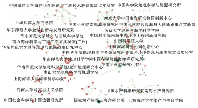
The South China Sea has emerged as a focal region in geographical research. This study reviews the progress of geographical scholarship on the South China Sea in China, drawing upon the four classical traditions of geography: the Spatial Tradition, Area Studies Tradition, Man-Land Tradition, and Earth Science Tradition. Research grounded in the Spatial Tradition primarily employs geographic information technologies to analyze the spatial distribution of reefs and infrastructure, and utilizes cartographic and critical mapping approaches to represent territorial elements and construct sovereignty narratives. Studies rooted in the Area Studies Tradition focus on characterizing the regional features and local contexts of Hainan Island, the South China Sea, and its surrounding areas. Research under the Man-Land Tradition examines the historical evolution of man – sea relationships and the production of local knowledge. Earth Science Traditionbased studies mainly address marine monitoring, scientific expeditions, natural regionalization, and development assessments of the South China Sea. Furthermore, this paper identifies three key directions for future geographical research on the South China Sea—data integration, mechanism exploration, and strategic formulation. Future research should build upon the integration of the four major traditions of geography to establish a comprehensive analytical framework of "pattern-process-mechanism-governance, " linking data, processes, and decision-making.
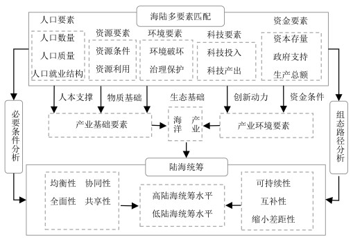
Utilising dynamic fuzzy set qualitative comparative analysis(QCA) on panel data from 11 coastal provinces(municipalities and autonomous regions) in China spanning 2012 to 2022, this study investigates the configurational pathways through which multi-factor matching impacts integrated land-sea planning.This methodological approach is instrumental in investigating the configurational pathways and necessary conditions through which multi-factor matching impacts the realisation of integrated land-sea planning objectives. The findings reveal: 1) Between the years 2012 and 2022, there has been a consistent enhancement in the levels of multi-factor matching and integrated planning across all provinces, accompanied by the observation of significant spatial disparities. 2) High-level integrated planning configurations encompass three distinct models.
With the development of rural tourism and homestays, increasing numbers of women are choosing to settle in rural areas to establish new careers and identities. Studying the identity construction of rural female homestay owners can enrich the theory of identity construction from a gender perspective. This research focuses on rural female homestay owners in Shennongjia and employs qualitative methods such as participant observation and in-depth interviews to construct a three-stage model of their identity construction process: identity reconstruction, identity balance, and identity recognition. The research finds that the identity crisis and identity needs arising from the villagers' and femal identities drive the expansion of the homestay owners' identity under the joint influence of identity opportunities. Through the integration of multiple roles as "mother and wife, " "villager, " and "business operator" within a multi-dimensional space, female homestay owners achieve identity balance. Self-identity and social-identity are important indicators for successfully constructing the identity of rural female homestay owners. The research provides an empirical framework for gender studies in rural tourism and has practical implications for optimizing policies for women's entrepreneurship, activating endogenous development in rural areas and promoting rural revitalization.
The relaxation of restrictive fertility policies has not reversed the declining trend of fertility rates in China, indicating that family intentions to have a second child are shaped by a complex array of factors. This study explores the impact mechanism of the community environment on families' second-child willingness from four dimensions: environmental safety, environmental comfort, facility abundance, and service friendliness. Based on questionnaire survey data from 308 families with children aged 0—6 in Xi'an, this study employs binary and sequential Logit models and Structural Equation Modeling for empirical analysis. The results show that: 1) Families' second-child fertility intentions are significantly correlated with their parenting emotions. Positive parenting experiences significantly enhance second-child fertility intentions, while parenting burnout suppresses them; 2) Parenting emotions serve as a mediating factor in how external environments influence the intention to have a second child. 3) Community environment is of great significance for enhancing second-child fertility intentions. 4) Community environment also indirectly alleviates parenting burnout by supporting outdoor childcare activities on weekdays, with the accessibility of leisure and medical facilities and the child-participatory nature of community activities acting as key driving factors; 5) Family environment and individual circumstances are also crucial for improving second-child fertility intentions, especially the importance of work-family balance.
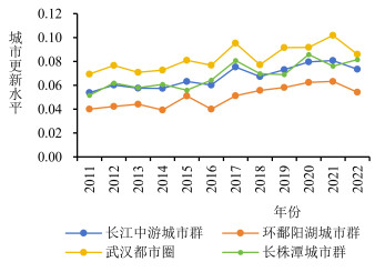
Using the entropy weight method, Dagum Gini coefficient method, and spatial econometric models, this paper analyzes the spatiotemporal evolution characteristics, regional differences, and influencing factors of urban regeneration in the study area from 2011 to 2022.The main conclusions are as follows: 1) In terms of temporal evolution, the level of urban regeneration in the study area exhibits a fluctuating trend of "rise-decline-rise", eventually showing a gradual upward trend.2) Regarding spatial differentiation and regional disparities, at the urban agglomeration level, the Wuhan Metropolitan Area consistently leads, while the urban agglomeration around Poyang Lake lags behind for a long time.3) In terms of influencing factors, financial development, openness to the outside world, population agglomeration, and economic development level have positive effects on local urban regeneration.
Cross-regional risk activities reflect the economic linkages between regions, and the urban networks they construct provide a unique perspective for identifying inter-city relationships in flow spaces. This study uses the national venture capital data from 2000 to 2018 to construct a city network, uses two methods: absolute correlation and relative correlation to identify the hinterworld scope and spatial evolution pattern of the Guangdong-Hong Kong-Macao Greater Bay Area, and summarizes the spatial evolution characteristics of the hinterworld of the Greater Bay Area based on venture capital flow. The results show that: 1) In terms of urban network, the total correlation and network correlation degree of cities in China show an obvious gradient pattern, and the urban network development is more perfect. 2) In terms of hinterworld, the number and spatial scope of the hinterworld in the Guangdong-Hong Kong-Macao Greater Bay Area showed an expanding trend, but the scope of the core hinterworld did not change much, concentrated in the adjacent areas south of the Yangtze River Basin, showing the characteristics of fragmented distribution, high overlap, proximity and marginalization; 2) The spatial pattern and evolution of the hinterworld in the Guangdong-Hong Kong-Macao Greater Bay Area mainly present two static characteristics: distance attenuation and spatial heterogeneity, and two dynamic evolution characteristics: regional contiguity and expansion of the competitive hinterworld.
Grounded in tourism corridor theory, this study analyzes the spatial distribution characteristics of industrial heritage in the Yangtze River Economic Belt (YREB) by examining 169 representative industrial heritage sites across 11 provinces. Utilizing kernel density analysis and the Minimum Cumulative Resistance (MCR) model, a comprehensive tourism corridor system for industrial heritage is constructed to reveal spatial patterns and development potential. The findings indicate the following: 1) The industrial heritage resources within the YREB exhibit remarkable diversity, encompassing six major industrial sectors, including manufacturing, electricity and water production and supply, mining, scientific research and technical services, education, and transportation. 2) The spatial pattern of industrial heritage reveals a significant agglomeration structure, which can be summarized as "two cores and one belt." This configuration aligns closely with the east-west orientation of the Yangtze River, along which the majority of industrial heritage sites are distributed. The Yangtze River Delta and the Chengdu-Chongqing region emerge as the primary high-density core clusters, benefiting from their historical industrial foundations and strong economic bases. In contrast, the four central provinces—Hunan, Hubei, Jiangxi, and Anhui—form a secondary agglomeration zone, exhibiting a planar and relatively dispersed spatial distribution.3) Based on spatial clustering results, the industrial heritage tourism corridor system is structured into three regional sub-corridors, six optimal connectivity routes, and six key node cities. These nodes—Shanghai, Wuhan, Zhuzhou, Jingdezhen, Chengdu, and Chongqing—serve as focal points for corridor development and regional coordination.
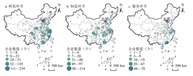
The low-altitude economy is exerting a significant influence on China's existing industrial landscape, yet its industrial network structure and driving factors remain a "black box." This study compiles data and information from China's low-altitude economy companies listed on the A-share, Hong Kong stock, and New Third Board markets, selecting representative enterprises established before December 31, 2024. Based on headquarters-branch linkages, we construct a low-altitude economy industrial network in China and investigate its spatial characteristics and influencing factors. The findings reveal that: 1) The spatial distribution of China's low-altitude economy enterprises exhibits a distinct "core-periphery" structure, with functional specialization across different segments of the value chain. 2) The topology of the inter-city networks formed by these linkages varies significantly by function. The R&D network is polycentric in structure, reliant on knowledge flows and collaborative innovation between high-tier cities possessing robust scientific capabilities and talent pools. 3) The co-evolution of technology and institutions is the central driver of network formation. Technological proximity and organizational proximity facilitate knowledge exchange and collaborative agglomeration, while policy guidance and environmental variations shape the overall network architecture.
Focusing on the Shandong Peninsula urban agglomeration, this study examines the spatiotemporal patterns and influencing factors of multilayer hinterland relationships within urban innovation networks from both national and local spatial perspectives. The analysis is based on a multilayer innovation network constructed from intercity patent transfers, scientific co-authorships, and venture capital investments, using data from the years 2010, 2015, 2020, and 2023. Three conclusions are drawn. First, in terms of self-network size, the proportion of weak components and reach efficiency, the Shandong Peninsula urban agglomeration has been increasingly integrated into China's multi-level innovation network, with its network structure gradually evolving towards a polycentric and decentralized pattern. Second, at the local scale, the multilayer hinterland ties are especially strong within the Provincial Capital Economic Circle and between it and the Jiaodong Economic Circle, while the Lunan Economic Circle exhibits relatively weak internal and external connections.At the national scale, multilayer hinterland linkages are primarily concentrated with cities in the BeijingTianjin-Hebei, Yangtze River Delta, and Guangdong-Hong Kong-Macao urban agglomerations. Third, the paired cities' innovation capacity, administrative rank, level of digital economy development, and high-speed rail connectivity have positive effects on multilayer hinterland relationships, while GDP gradients and geographic distance exert negative impacts.
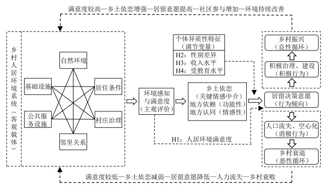
Rural residents' settlement intention is a critical indicator for assessing rural development potential and sustainability. Based on the "Environment Perception–Place Attachment–Settlement Decision" framework, this study analyzes 360 survey responses from Huangmen Town using binary logistic regression to explore perceptions, group disparities, and influencing factors. The results indicate that: 1) Residents are generally satisfied with their living environment(mean=3.31), with neighborhood relations scoring highest and public service facilities lowest. 2) Significant group differences exist, where settlement intention correlates positively with environmental satisfaction; females exhibit higher intentions than males, while education and income levels are significantly and negatively correlated with these intentions. 3) Current village living environment, cultural and recreational facilities, healthcare services, transportation infrastructure, the administrative capacity of village cadres, and neighborhood relations all exert positive impacts on residents' settlement decisions.
This article takes Mangkuan Township in Yunnan Province as a research example to deeply analyze the theoretical logic, mechanism of action and practical path of characteristic cultural festivals in promoting rural revitalization. Through the case analysis of multiple characteristic festivals in Mangkuan Township, such as the Torch Festival, Kuoshi Festival, Water-Splashing Festival, Mango Culture Festival, and Lychee Culture Festival, the specific mechanisms they have in promoting the deep integration of agriculture and tourism. Research shows that: 1) Characteristic cultural festivals play a significant role in enriching the modern rural industrial system, guiding villagers to establish an "ecological concept", promoting the construction and strengthening of rural identity, giving full play to the advantages of cultural governance, and expanding villagers' income channels. 2) Complete supporting infrastructure, rich local tourism resources, strong festival brands, a variety of exciting festival activities and extensive participation of villagers can greatly enhance the role of characteristic cultural festivals in promoting rural revitalization.
Focusing on Xinzhai Village in Yunnan and employing ethnographic methods, this study explores the process and mechanisms by which industrial integration promotes rural transformation in ethnic minority areas from the perspective of "element-structure-function". The findings reveal that with changes of rural exogenous system elements such as the national rural revitalization strategy, industrial integration development policies, and shifts in domestic market demand, traditional agriculture has expanded beyond its original scope, intertwining with culture and tourism, thereby reshaping the multidimensional structure of rural areas.This has caused rural core system elements, including land, capital, and labor, to flow and recombine, thereby reshaping the multidimensional structure of rural areas. This has established an inter-promoting cooperative networks centered on party organizations and collective cooperatives. It has also created an economic system where the three industries grow together. Additionally, the preservation and development of local Dai culture have strongly contributed to shaping rural communities, fostering a sense of ethnic identity and belonging among villagers, thus providing emotional support and a foundation for coordination in sustainable rural development. At the same time, the expansion of green spaces for ecological conservation has progressively improved the rural living environment. Finally, with the structural changes, ethnic minority areas are transforming towards multifunctional countryside.
Current empirical studies have largely examined the linear effect of rail transit accessibility on land values, but few explore their non-linear correlations by machine learning. To fill this understanding gap, by using the city of Ningbo as an example, this paper examines the non-linear effects of location, neighborhood, and parcel characteristics on land prices through a gradient-boosted decision tree(GBDT) model. The land transaction data and point-of-interest(POI) data of various types of public services are employed. The findings show that: 1) The distance from the parcel to the nearest rail transit station ranks 5 th in relative importance among these variables and exerts an influence on land prices. 2) High-speed rail accessibility has a "U-shape" non-linear impact on land prices; the effects of POIs like shopping, scenic, and medical facilities on land prices show a general trend transforming from a negative to a positive correlation. 3) Compared with the hedonic pricing models, GBDT has a better degree of fitting result, which reflects the advantages of machine learning. 4) The effective thresholds of rail transit accessibility on the land value premium of residential and commercial parcels are 4 km and 2.2 km respectively, and the threshold effect on industrial land price appreciation is insignificant.
Traditional villages face two interrelated pressures: the overwhelming influx of external resources and the continual insufficiency of endogenous driving forces. Taking as its foundation an analytical framework for the new endogenous development of traditional villages-structured around the sequential logic of"system structure-system function-system strategy". This paper conducts a case study of Zhangguying Village in Hunan Province. By employing three-level open coding, the study identifies key developmental variables, which are then integrated with system dynamics methods to analyzes the mechanisms of new endogenous development and its practical pathways in Zhangguying Village. The research results can be summarized in three main points: 1)The new endogenous development system of Zhangguying Village is primarily constituted by three broad categories of elements: behavioral actors, development resources, and institutional rules. 2)The mechanism of new endogenous development in Zhangguying Village can be delineated into three interrelated subsystems: the exogenous system, the endogenous system, and the integrated system that combines internal and external dynamics. 3) Zhangguying Village has gradually formed three practical pathways: resource-coordinated embedding, actor collaboration and co-governance, and value identity-driven development.
Against the backdrop of ongoing rural population decline and the weakening of community subjectivity, tourism-based villages face a pressing challenge: how to reconstruct sustainable local support systems.Traditional approaches to community development often rely on the long-term participation of permanent residents; however, in depopulated and aging regions, such models are increasingly unsustainable. In response, this study takes the Yuki-tōrō Supporter Program in Kayabuki-no-Sato, Miyama Town, Kyoto Prefecture, Japan, as a case study. Grounded in subjectivity theory and based on qualitative methods including participant observation and semi-structured interviews, the research focuses on tourists as "mobile subjects" and explores how their short-term involvement in tourism-based community development can contribute to the regeneration of village subject structures. Findings reveal that tourists demonstrate distinct characteristics of subjectivity through their participation: 1) self-driven motivation and active practice rooted in personal interest, cultural identification, and value pursuit; 2) dynamic role negotiation between being service providers and experience seekers; and 3) the accumulation of subjective experience through repeated participation and cross-regional mobility. Based on these insights, the study proposes a threefold mechanism for village subject regeneration: first, the institutional empowerment of tourists through the creation of short-term participation platforms to activate and convert their subjectivity into localized support resources; second, the dynamic balancing of service obligations and individual experience needs through flexible role coordination; and third, the spatial and temporal extension of tourist subjectivity as a foundation for building regenerative support networks across regions.
The construction of national night-time cultural and tourism consumption agglomeration areas plays a significant role in stimulating consumption growth and meeting the growing needs of people's quality of life. This study takes the three batches of agglomeration areas in China as the research object. Using geographic spatial feature analysis methods such as kernel density estimation, nearest neighbor index, and standard deviation ellipses, the spatial distribution patterns of the agglomeration areas are analyzed. Additionally, the optimal parameter geographic detector is employed to reveal the driving mechanisms behind their spatial heterogeneity. The results show: 1) The spatial distribution of agglomeration areas is uneven, presenting a clustering pattern of "more in the east and fewer in the west" and "stronger in the south and weaker in the north." 2) The type structure of agglomeration areas is diverse, and spatial heterogeneity is significant. The overall spatial density displays characteristics of "two primary cores, two secondary cores, and multiple peripheral areas." The two main cores are the high-density regions of the Yangtze River Delta and the Beijing-Tianjin-Hebei urban agglomerations. 3) The spatial distribution pattern of agglomeration areas presents a narrow shape along the northeast-southwest direction. 4) The spatial distribution pattern of agglomeration areas is the result of the combined influence of socioeconomic foundations, tourism development levels, historical and cultural environments, public service capacities, policy environments, and natural environments.
With the growing popularity of driving tours as a prominent form of tourism, automobiles, as the core carriers, have become deeply integrated into the tourism system. However, their agency in constructing tourism networks remains underexplored. Drawing on actor-network theory and empirical data from four long-distance driving trips, this study examines the materiality of automobiles in driving tourism and their role in shaping relational networks. The findings reveal three key dimensions: First, automobiles reconstruct spatial meanings as "mobile habitation spaces." Amid the tension between enclosure and mobility, they sustain tourists' sense of security and belonging while being constrained by infrastructure and technical systems.Second, as "taskscape shapers, " the "mobility-mooring" rhythm reshapes the temporal logic of tourism, facilitates the "generalization of attractions, " and connects tourists with communities to form dynamic consumption networks. Third, automobiles regulate diverse relational networks through "territorialization mechanisms" and "disparities in mobility capacity." Within road spaces, competition for right-of-way between motor vehicles and other road users constructs implicit "power territories, " while the speed advantage and technical thresholds of automobiles exacerbate relational inequalities among tourists, local residents, slow travelers, and the natural ecosystem.